Dagala Trek
The Dagala Trek, also known as the Thousand Lake Trek, is a 50 km trek in the Thimphu district of Bhutan.The trail starts at Genekha and ends at Chamgang, and includes four passes, one of which is over 4,500 meters. The trek is considered moderate, with the highest altitude at 4,300 meters.
The Dagala Trek follows the ridgeline of the Dagala range, which separates the Thimphu valley from the lower hills to the south. On a clear day, you can see the peaks of Bhutan, Sikkim, and Nepal. The trek also includes a tour of Thimphu, Punakha, and Paro.
Upon arrival at Paro airport, you will be received by our guide and representative, and will escort you to the hotel. In the afternoon your series of visits begin with an errand to Ta Dzong, an ancient watchtower, which now is the National Museum. Below the museum is the Paro Rinpung Dzong, the centre of civil and religious authority in this valley. It is believed that this fortress is built on the heap of jewels in 15th century.
A short walk takes you to the base of the dzong and across a traditional cantilevered, covered bridge. In the evening start sorting and packing your trekking equipment for the trek you will start tomorrow.
Drive towards the road point to Taktsang. Taktsang is the place most visited by both the tourists and Bhutanese. Taktsang Monastery, the most famous of Bhutan’s monasteries is perched on the side of a cliff 900m above the Paro valley floor. Taktsang means “Tiger’s Nest,” so named because Guru Rinpoche reportedly flew to the site of the monastery on the back of a flying tigress. This day hike is not only historically and culturally interesting, but also incredibly scenic! It takes about one and half hour to reach the cafeteria, which gives a breathtaking view of the Tiger’s Nest. If you still feel like hiking then you can take another hour to reach the temple. Then return back to the cafeteria for your lunch and then walk down hill after your lunch. You will be driven back to the hotel from the base camp.
Distance 7Km, Time 5 hours, Camp Eleve 3290m.
Today, we will drive to Thimphu (Genekha 2800M) which is the starting point of our trekking. Today’s trail is all through terraced fields and conifers vegetation. Trek starts with a short descent down to the river, from here, after crossing the river, you start climbing till you reach a huge rock platform at 3350m from where you will have a picturesque view of the valley below. After another 2 hours, you reach Gur amid yak pastures at 3290m.
Distance 12Km, Time 6 hours, Camp Elev 4100m.
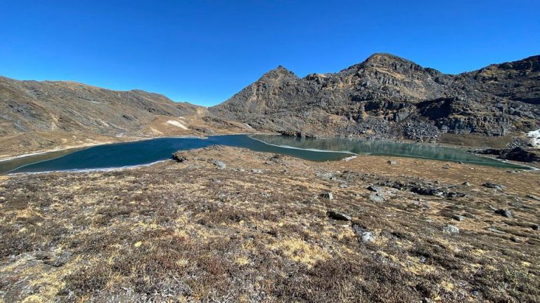
While trekking across the ridges, one enjoys beauty of the rugged mountains vegetation. The path winds through flowers and wild asparagus (in spring). The meadows are refreshing and inspiring. The first pass symbolize by a huge cairn gives a spectacular view of Kanchenjunga (Sikkim) and more or less all the Bhutanese Himalayan peaks. Once descended into the Lamatama valley, you will ascend gradually through the valley passing some yak herder huts till you reach Utsho Lake where golden trouts are in abundance.
The campsite is right next to the lake at 4100.
Distance 8Km, Time 5-6 hours, Camp Elev 400m.
The trail continues along the western side of the Dalatsho up to a saddle at 4520m from where you can have majestic view of Himalayan peaks during descent. This point is around 4460m. The mountain peaks include Everest (Nepal), Kanchenjunga (Sikkim), Jumolhari, Jitchu Drake, Tshering Gang, Khangbum, Masa Gang , Tshenda Gang and Gangche Ta. If you want even better view, you can climb a peak close to the saddle with an altitude of 4720m. From the saddle the path descends, passing some yak herder huts (you can interact with them to know their livelihood) to Docha Chu. You follow the river for a while, but stay higher up on the slop to reach Pankha with some ups and down on the way. Camp at Pankha is about 4000m.
Distance 14Km, Time 8 hours,
You will start early today. This day entails the crossing of several passes, each one more impressive than the other. Search for different varieties of plants and mountain birds. After crossing the last small ridge, you will gradually decent toward the main Junction pass, which crisscrossed each other for the trail towards Chamgang, Talekha, Ganekha and Gaselo. So just make a very short descent on your right, and then take left horizontally for few minutes towards Chamgang trail with about three to four small ridges to go up and down before you begin a steep downhill hike until you reach a Chamgang village. You will finally arrive at the motor able road where transport will be awaiting to transfer you to Thimphu.
Depart from Paro International Airport

